 I can say this without spoiling anything, but the epilogue to Becoming Little Shell begins with reflections from “a little green house high on a hillside that overlooks Butte, Montana.” It is mid-November of 2021 and, as I wrote, I was in that house enjoying a residency where I largely completed the first draft of the book. I’ll admit now though that if someone had told me then that BLS wouldn’t actually be out in the world for the better part of another three years I would have been dismayed to the point of proclaiming, “I will never survive that!” But it took that long, I survived, and here we are.
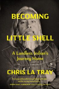
I mention that residency, that little green house, because it was also during my stay there that I had my first meeting with the entire Milkweed team. We did it via Zoom, all of their lovely faces occupying tiny rectangular boxes on the display of my laboring old laptop while I sat at the kitchen table drinking coffee on a sunny and beautiful morning. This meeting was an introduction to each other of sorts, though I knew a few of them, and I had to talk about the book, who I imagined it being for, etc. Toward the end of the discussion I was asked, “Do you have any ideas about what you might want to see on the cover?”
I had vague ideas at the time – they certainly didn’t include my catcher’s-mitt-of-a-face (as described by my PNW-based, renowned graphic designer and fellow hirsute and man-of-size friend, Aaron Draplin) occupying it – but I didn’t say much about that. Instead, I wanted to talk about: a map.
Yes, there is a map on the inside cover of Becoming Little Shell. It was created by my cartographer friend Amelia Hagen-Dillon and is far and away my favorite thing aesthetically about the book. It depicts the “Métis Archipelago”, a description coined by my late friend and mentor Nicholas Vrooman to describe the island-like diaspora of communities occupied by not just my Métis and Chippewa ancestors, but by current members of today’s Little Shell tribe. As I told my comrades at Milkweed, having a map was important not just as a visual narrative of how my people were dispersed by colonialism and land theft, but also a kind of nod to the formative years of my relationship to literature: binding-bursting fantasy novels.
When I was a kid (and even today, really) the stuff I loved to read the most came with maps. Beautiful maps that set my mind off to flights of magnificent fancy. Tolkien’s Middle Earth. The Hyboria of the Conan the Barbarian tales from Robert E. Howard (my home wifi network is called Hyboria, in fact). Le Guin’s Earthsea. Even Jack London’s Alaska had me poring over maps and imagining myself somewhere out there, staring off into their howling spaces.
There isn’t much of a stretch from those squiggly lines and indicators of mountains and rivers and forests of imagined worlds that stirred my eager and adventurous spirit to finding the same wonder in the wild immensity of the western half of Turtle Island, the hunting and wandering country of my not-so-distant ancestors. I learned long ago that I would never be a Cimmerian like Conan; instead I found myself in steely-eyed Métis like Gabriel Dumont, one of the greatest real-life legends of the high plains. In those occasional moments when people dare to suggest I “don’t look like an Indian” I need only hold up a photograph of the brave Indigenous patriots who died with Louis Riel fighting the Canadians and prove that my face fits perfectly among them. They would look upon me and know me. The beauty of it is that I’m able to traverse the same open landscapes as they did in their quest for Métis independence, a quest that continues today on both sides of the Medicine Line.
Which is to say this: that map includes a big chunk of the Pacific Northwest and, had we had space for it in the book, we might have extended the image all the way to the Pacific Ocean as our diaspora does. The story of the Red River Métis and the Pembina and Little Shell Chippewa is the story of this region, or a huge part of it anyway. The narrative of the map also supports the narrative of why I have been so moved by the readers of this region who have chosen to celebrate my book as being among the best of 2024. This region is our home and we have been rooted in it for centuries, with kinship networks threading us even farther back in time. I want everyone here to know about my people; to know our story, one that has been targeted for erasure for generations. I like to think that that effort fails here, with this book, with the awareness of everyone who reads it and hopefully comes away knowing something they might not have otherwise, and acting and living perhaps a little differently than they may otherwise have.
So for you, my PNW relatives, my gratitude for your time and attention is mightier than the Red River of the North, from which our story is born, and flows not just north, but west all the way to the sea.
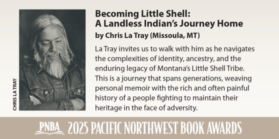
Fact & Fiction and the Missoula Public Library in Missoula, MT are planning celebrations for Chris La Tray’s Pacific Northwest Book Award for April 23, 2025. The dual-location event will feature a reading at the library followed by refreshments and the award presentation at the store, which is just a few blocks away.
Watch this site for information about the Pacific Northwest Book Award winner events hosted by independent bookstores around the region.
NWbooklovers posts original essays from this year’s award winners as featured posts in January and February. You can enjoy essays from past winners of the PNBA Book Award in our archive.